| Yosemite National Park [2020年7月] |
 |
| ... |
|
|
|
|
| Manzanar National Historic Site [2020年7月] |
|
| ... |
|
|
|
|
| Ancient Bristlecone Pine Forest [2020年7月] |
|
| ... |
|
|
|
|
| Devils Postpile National Monument [2020年7月] |
|
| ... |
|
|
|
|
| Tahoe Basin [2020年6月] |
|
| ... |
|
|
|
|
|
|
|
|
|
| Tioga Pass Road [2019年8月] |
|
| ... |
|
|
|
|
| Carrizo Plain National Monument [2019年4月] |
|
| ... |
|
|
|
|
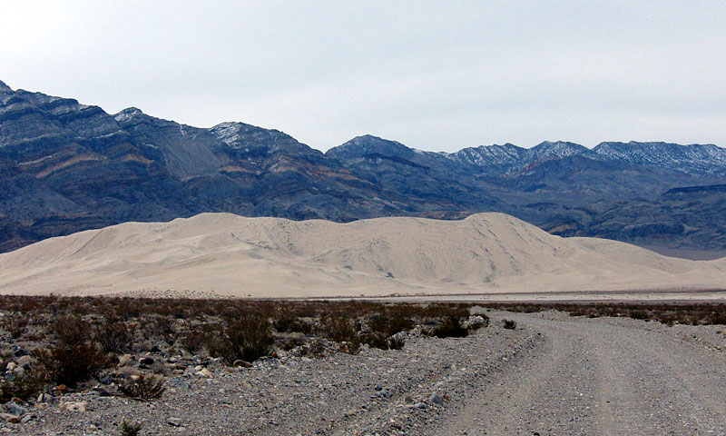
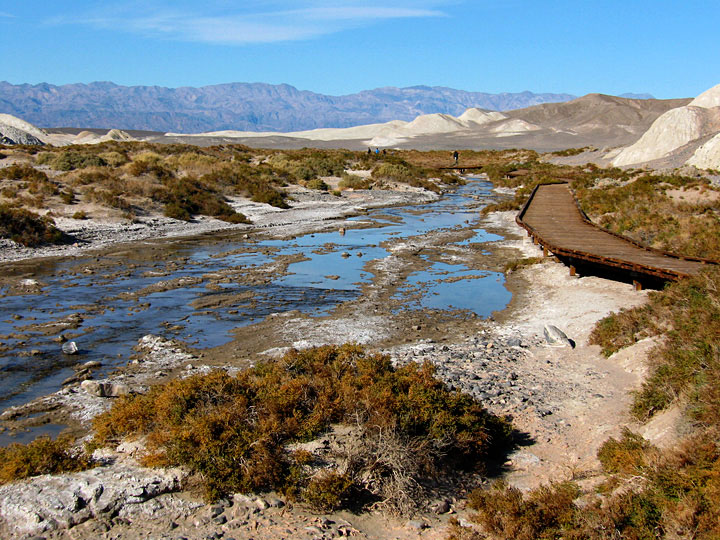
| Death Valley National Park [2019年3月] |
|
| ... |
|
|
|
|
| シエラ・ネバダ・トラバース (Sierra Nevada Traverse) [2018年8〜10月] |
|
![[IMG_9716+.jpg]](./pct-2018/d42/thumbs/IMG_9716+.jpg) |
|
![[IMG_3671.jpg]](./pct-2018/d81/thumbs/IMG_3671.jpg) |
|
![[IMG_0226_6.jpg]](./pct-2018/d83/thumbs/IMG_0226_6.jpg) |
|
| Bear sighting on Day 2 |
|
Upper Rae Lake |
|
Palisades from Mather Pass |
|
|
![[IMG_5075+76.jpg]](./pct-2018/d95/thumbs/IMG_5075+76.jpg) |
|
![[IMG_7094+.jpg]](./pct-2018/d118/thumbs/IMG_7094+.jpg) |
|
![[IMG_0519.jpg]](./pct-2018/d136/thumbs/IMG_0519.jpg) |
|
| from Silver Pass |
|
Forsyth Peak and Dorothy Lake |
|
Pyramid Peak and Lake Aloha
(Desolation Wilderness) |
|
|
|
|
|
| ジョン・ミュア・トレイル (John Muir Trail) [2018年8〜9月] |
|
![[IMG_4053+.jpg]](./pct-2018/d83/thumbs/IMG_4053+.jpg) |
|
![[IMG_4499_1.jpg]](./pct-2018/d86/thumbs/IMG_4499_1.jpg) |
|
![[IMG_4839+.jpg]](./pct-2018/d90/thumbs/IMG_4839+.jpg) |
|
| Lake Marjorie |
|
Muir Pass |
|
Marie Lake from Selden Pass |
|
|
![[IMG_5784+.jpg]](./pct-2018/d104/thumbs/IMG_5784+.jpg) |
|
![[IMG_6011.jpg]](./pct-2018/d106/thumbs/IMG_6011.jpg) |
|
![[IMG_0381.jpg]](./pct-2018/d107/thumbs/IMG_0381.jpg) |
|
| Banner Peak and Garnet Lake |
|
Lyell Fork |
|
Cathedral Peak and Upper
Cathedral Lake |
|
|
|
|
|
| マウント・ホイットニー (Mount Whitney) [2018年8月] |
|
![[IMG_2478+.jpg]](./pct-2018/d71/thumbs/IMG_2478+.jpg) |
|
![[IMG_2506.jpg]](./pct-2018/d71/thumbs/IMG_2506.jpg) |
|
![[IMG_2538.jpg]](./pct-2018/d71/thumbs/IMG_2538.jpg) |
|
Mt. Hitchcock and Hitchcock Lakes
from John Muir Trail |
|
Mt. Whitney summit seen |
|
Summit Shelter |
|
|
![[IMG_0166.jpg]](./pct-2018/d71/thumbs/IMG_0166.jpg) |
|
![[IMG_2568.jpg]](./pct-2018/d71/thumbs/IMG_2568.jpg) |
|
![[IMG_2574.jpg]](./pct-2018/d71/thumbs/IMG_2574.jpg) |
|
Mt. Williamson, Trojan Peak, Mt.
Barnard, Mt. Hale and Mt.
Russell from summit |
|
Whitney Crest from summit |
|
Keeler Needle and Day Needle |
|
|
|
|
|
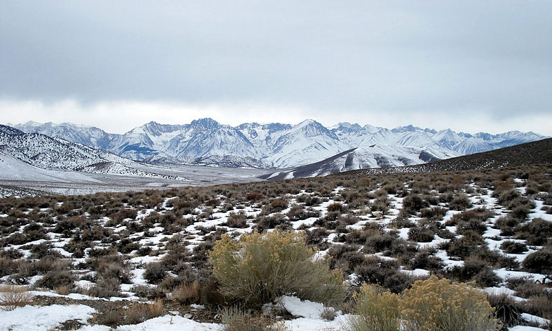
| Eastern Sierra Scenic Drive [2018年2月] |
|
| ... |
|
|
|
|
| Angeles Crest Highway [2017年10月] |
|
![[IMG_7024.jpg]](./angeles-crest-hwy-2/thumbnails/IMG_7024.jpg) |
|
![[IMG_7079.jpg]](./angeles-crest-hwy-2/thumbnails/IMG_7079.jpg) |
|
![[IMG_7103+.jpg]](./angeles-crest-hwy-2/thumbnails/IMG_7103+.jpg) |
|
CA 2 entering Angeles National
Forest |
|
Cloud Burst Summit |
|
Vincent Gulch Divide |
|
|
|
|
|
| Mono Lake South Tufa [2017年8月] |
|
| ... |
|
|
|
|
| Eastern Sierra Drive & Hike [2017年7月] |
|
| ... |
|
|
|
|
| Edison Lake and Florence Lake [2017年6月] |
|
| ... |
|
|
|
|
| Lassen Volcanic National Park [2017年6月] |
|
| ... |
|
|
|
|
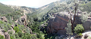
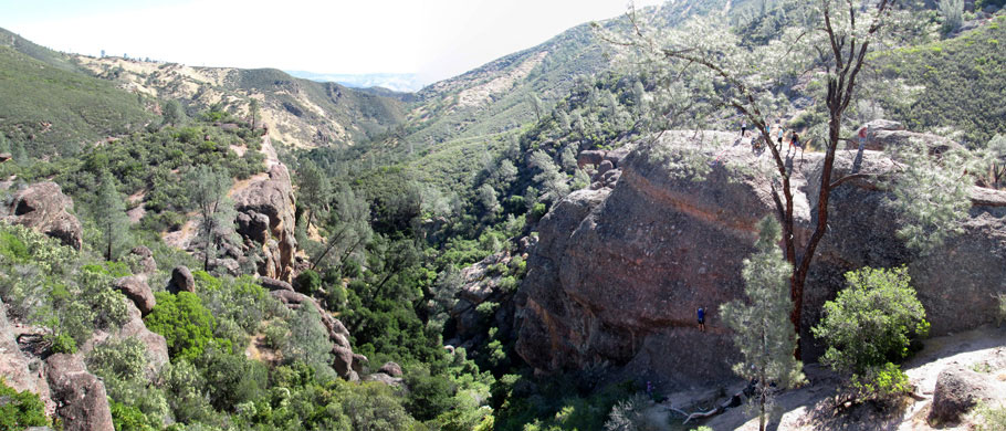
| ピナクルズ・ナショナル・パーク (Pinnacles National Park) [2017年4月] |
|
![[IMG_5024.jpg]](./pinnacles-np-%2717/thumbnails/IMG_5024.jpg) |
|
![[IMG_5041+.jpg]](./pinnacles-np-%2717/thumbnails/IMG_5041+.jpg) |
|
![[IMG_5071+.jpg]](./pinnacles-np-%2717/thumbnails/IMG_5071+.jpg) |
|
| North Wilderness Trail |
|
High Peaks and North Chalone Peak |
|
|
|
![[IMG_2956.jpg]](./pinnacles-np-%2717/thumbnails/IMG_2956.jpg) |
|
![[IMG_5101.jpg]](./pinnacles-np-%2717/thumbnails/IMG_5101.jpg) |
|
![[IMG_2967+.jpg]](./pinnacles-np-%2717/thumbnails/IMG_2967+.jpg) |
|
Balconies from Old Pinnacles
Trail |
|
Baloconies Caves Trail |
|
Machete Ridge from Balconies Trail |
|
|
|
|
|
|
|
|
|
|
|
|
|
|
|
| アラバマ・ヒルズ (Alabama Hills) [2017年3月] |
|
![[IMG_4833.jpg]](./alabama-hills-%2717/thumbnails/IMG_4833.jpg) |
|
![[IMG_4834.jpg]](./alabama-hills-%2717/thumbnails/IMG_4834.jpg) |
|
![[IMG_4837.jpg]](./alabama-hills-%2717/thumbnails/IMG_4837.jpg) |
|
Arch Loop Trail (Mobius Arch
Trail) |
|
Lathe Arch |
|
|
![[IMG_4844.jpg]](./alabama-hills-%2717/thumbnails/IMG_4844.jpg) |
|
![[IMG_4852.jpg]](./alabama-hills-%2717/thumbnails/IMG_4852.jpg) |
|
![[IMG_2888.jpg]](./alabama-hills-%2717/thumbnails/IMG_2888.jpg) |
|
| Mobisu Arch |
|
from Mobisu Arch Trail |
|
|
|
|
|
|
| Redwoods National Park [2016年12月] |
|
| ... |
|
|
|
|
|
|
|
|
|
| Carrizo Plain National Monument [2016年11月] |
|
| ... |
|
|
|
|
|
|
|
|
|
|
|
|
|
|
|
|
|
|
|
| Ancient Bristlecone Pine Forest [2016年5月] |
|
![[IMG_2268.jpg]](./ancient-bristlecones-%2716/thumbnails/IMG_2268.jpg) |
|
![[IMG_2273+.jpg]](./ancient-bristlecones-%2716/thumbnails/IMG_2273+.jpg) |
|
![[IMG_2275+.jpg]](./ancient-bristlecones-%2716/thumbnails/IMG_2275+.jpg) |
|
| Schulman Grove |
|
Ancient Bristlecone Pine Forest Visitor
Center (Schulman Grove Visitor Center) |
|
Discovery Trail / Methuselah Trail |
|
|
|
|
|
|
|
|
| Manzanar National Historic Site [2016年5月] |
|
![[IMG_2138+.jpg]](./manzanar-%2716/thumbnails/IMG_2138+.jpg) |
|
![[IMG_2147+.jpg]](./manzanar-%2716/thumbnails/IMG_2147+.jpg) |
|
![[IMG_2158.jpg]](./manzanar-%2716/thumbnails/IMG_2158.jpg) |
|
| Manzanar National Historic Site |
|
Manzanar Cemetery |
|
Manzanar Reservoir |
|
|
![[IMG_2174.jpg]](./manzanar-%2716/thumbnails/IMG_2174.jpg) |
|
![[IMG_2178++.jpg]](./manzanar-%2716/thumbnails/IMG_2178++.jpg) |
|
![[IMG_2192.jpg]](./manzanar-%2716/thumbnails/IMG_2192.jpg) |
|
| Manzanar Chicken Ranch |
|
Mess Hall Garden |
|
Historic Entrance / "Manzanar
War Relocation Center" |
|
|
|
|
|
| Alabama Hills [2016年5月] |
|
![[IMG_1637+.jpg]](./alabama-hills-%2716/thumbnails/IMG_1637+.jpg) |
|
![[IMG_2079+.jpg]](./alabama-hills-%2716/thumbnails/IMG_2079+.jpg) |
|
![[IMG_2081.jpg]](./alabama-hills-%2716/thumbnails/IMG_2081.jpg) |
|
| Mount Whitney from off Movie Road |
|
Lone Pine Peak |
|
Mount Langley |
|
|
|
|
|
| Giant Sequoia National Monument [2016年5月] |
|
| ... |
|
|
|
|
| ピナクルズ・ナショナル・パーク (Pinnacles National Park) [2016年4月] |
|
![[IMG_1773+.jpg]](./pinnacles-np-%2716/thumbnails/IMG_1773+.jpg) |
|
![[IMG_1806.jpg]](./pinnacles-np-%2716/thumbnails/IMG_1806.jpg) |
|
 |
|
| High Peaks from Peaks View |
|
Bear Gulch Reservoir |
|
Bear Gulch from Rim Trail |
|
|
![[IMG_1826.jpg]](./pinnacles-np-%2716/thumbnails/IMG_1826.jpg) |
|
![[IMG_1465_2.jpg]](./pinnacles-np-%2716/thumbnails/IMG_1465_2.jpg) |
|
![[IMG_1867.jpg]](./pinnacles-np-%2716/thumbnails/IMG_1867.jpg) |
|
| Scout Peak from High Peaks Trail |
|
High Peaks |
|
descending High Peaks Trail |
|
|
|
|
|
| Hetch Hetchy Valley & Cherry Lake Road [2016年3月] |
|
![[IMG_1604+.jpg]](./hetch-hetchy-valley-%2716/thumbnails/IMG_1604+.jpg) |
|
![[IMG_1610+.jpg]](./hetch-hetchy-valley-%2716/thumbnails/IMG_1610+.jpg) |
|
![[IMG_1628.jpg]](./hetch-hetchy-valley-%2716/thumbnails/IMG_1628.jpg) |
|
| Hetch Hetchy Valley |
|
O'Shaughnessy Dam and
Hetch Hetchy Reservoir |
|
Hetch Hetchy Dome, Kolana Rock
and Hetch Hetchy Reservoir |
|
|
![[IMG_1656.jpg]](./hetch-hetchy-valley-%2716/thumbnails/IMG_1656.jpg) |
|
![[IMG_1670.jpg]](./hetch-hetchy-valley-%2716/thumbnails/IMG_1670.jpg) |
|
![[IMG_1729+.jpg]](./hetch-hetchy-valley-%2716/thumbnails/IMG_1729+.jpg) |
|
| Tueeulala Falls |
|
Wapama Falls |
|
Cherry Lake |
|
|
|
|
|
| Carson Pass Highway [2016年2月] |
|
| ... |
|
|
|
|
| Mono Basin National Scenic Area [2015年10月] |
|
| ... |
|
|
|
|
| Tioga Pass Road [2015年10月] |
|
| ... |
|
|
|
|
| Devils Postpile National Monument [2015年10月] |
|
| ... |
|
|
|
|
|
|
|
|
|
| Death Valley National Park [2015年10月] |
|
| ... |
|
|
|
|
| 20 Lakes Basin [2015年7月] |
|
| ... |
|
|
|
|
| Channel Islands National Park [2015年7月] |
|
| ... |
|
|
|
|
| Death Valley National Park [2014年9月] |
|
| ... |
|
|
|
|
| Alabama Hills [2014年8月] |
|
![[IMG_2334++.jpg]](./alabama-hills-%2714/thumbnails/IMG_2334++.jpg) |
|
![[IMG_2338+.jpg]](./alabama-hills-%2714/thumbnails/IMG_2338+.jpg) |
|
![[IMG_2384+.jpg]](./alabama-hills-%2714/thumbnails/IMG_2384+.jpg) |
|
| Sierra Nevada from Tuttle Creek Road |
|
from above Tuttle Creek Road |
|
Movie Road entering Alabama
Hills Recreation Area |
|
|
![[IMG_2389.jpg]](./alabama-hills-%2714/thumbnails/IMG_2389.jpg) |
|
![[IMG_2399.jpg]](./alabama-hills-%2714/thumbnails/IMG_2399.jpg) |
|
![[IMG_2404+.jpg]](./alabama-hills-%2714/thumbnails/IMG_2404+.jpg) |
|
Mobius Arch Trail (Arch Loop
Trail) |
|
Sierra Nevada from Movie Road |
|
|
|
|
|
|
|
|
|
|
| Yosemite National Park [2014年5月] |
|
| ... |
|
|
|
|
|
|
|
|
|
| Sequoia & Kings Canyon [2014年4月] |
|
| ... |
|
|
|
|
| Giant Sequoia National Monument [2014年4月] |
|
| ... |
|
|
|
|
| Death Valley National Park [2014年2月] |
|
| ... |
|
|
|
|
|
|
|
|
|
|
|
|
|
|
| Alabama Hills [2013年2月] |
|
![[DSC04648+.jpg]](./alabama-hills-%2713/thumbnails/DSC04648+.jpg) |
|
![[DSC04684.jpg]](./alabama-hills-%2713/thumbnails/DSC04684.jpg) |
|
![[DSC04685.jpg]](./alabama-hills-%2713/thumbnails/DSC04685.jpg) |
|
Sierra Nevada (Mt. Whitney) from Tuttle Creek
Road |
|
Movie Road entering Alabama
Hills Recreation Area |
|
|
|
![[DSC04688+.jpg]](./alabama-hills-%2713/thumbnails/DSC04688+.jpg) |
|
![[DSC04694.jpg]](./alabama-hills-%2713/thumbnails/DSC04694.jpg) |
|
![[DSC04705.jpg]](./alabama-hills-%2713/thumbnails/DSC04705.jpg) |
|
| Mobius Arch Trail (Arch Loop Trail) |
|
Lathe Arch |
|
Mobius Arch |
|
|
|
|
|
| Death Valley National Park [2013年2月] |
|
| ... |
|
|
|
|
| Redwoods National Park [2012年11月] |
|
| ... |
|
|
|
|
|
|
|
|
|
| Death Valley National Park [2012年4月] |
|
| ... |
|
|
|
|
|
|
|
|
|
| Lone Pine Scenic Drive [2010年12月] |
|
![[3-01+.jpg]](./mojave-nat%27l-preserve%26death-valley-nat%27l-park/3-01+.jpg) |
|
![[3-05++.jpg]](./mojave-nat%27l-preserve%26death-valley-nat%27l-park/3-05++.jpg) |
|
![[3-18.jpg]](./mojave-nat%27l-preserve%26death-valley-nat%27l-park/3-18.jpg) |
|
Mt. Whiney from Dow Villa Motel,
Lone Pine |
|
Lone Pine Peak, Mt. Whitney and
Mt. Russell from Highway 136 |
|
Lone Pine Peak and Mt. Whitney
from Owenyo Road |
|
|
![[3-28.jpg]](./mojave-nat%27l-preserve%26death-valley-nat%27l-park/3-28.jpg) |
|
![[3-47+.jpg]](./mojave-nat%27l-preserve%26death-valley-nat%27l-park/3-47+.jpg) |
|
![[3-66+.jpg]](./mojave-nat%27l-preserve%26death-valley-nat%27l-park/3-66+.jpg) |
|
Mt. Whitney from Long
John Canyon Road |
|
Mt. Whitney from Tuttle Creek Road |
|
Split Mountain (in clouds), Mt.
Tinemaha and Taboose Creek Road from
Tinnemaha Road |
|
|
|
|
|
| デス・バレー・ナショナル・パーク (Death Valley National Park) [2010年12月] |
|
![[2-20+.jpg]](./mojave-nat%27l-preserve%26death-valley-nat%27l-park/2-20+.jpg) |
|
![[2-32.jpg]](./mojave-nat%27l-preserve%26death-valley-nat%27l-park/2-32.jpg) |
|
![[2-52+.jpg]](./mojave-nat%27l-preserve%26death-valley-nat%27l-park/2-52+.jpg) |
|
Death Valley Buttes, Hells Gate and
Daylight Pass Road |
|
Salt Creek Trailhead |
|
Scotty's Castle |
|
|
![[2-57+.jpg]](./mojave-nat%27l-preserve%26death-valley-nat%27l-park/2-57+.jpg) |
|
![[2-63.jpg]](./mojave-nat%27l-preserve%26death-valley-nat%27l-park/2-63.jpg) |
|
![[2-76.jpg]](./mojave-nat%27l-preserve%26death-valley-nat%27l-park/2-76.jpg) |
|
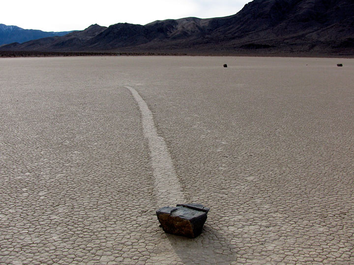
The Grandstand in The Racetrack
(Racetrack Playa) |
|
Moving Rocks in The Racetrack |
|
Hunter Mountain Road in
Cottonwood Mountains |
|
|
|
|
|
| モハヴィ・ナショナル・プリザーブ (Mojave National Preserve) [2010年12月] |
|
![[1-14+.jpg]](./mojave-nat%27l-preserve%26death-valley-nat%27l-park/thumbnails/1-14+.jpg) |
|
![[1-21+.jpg]](./mojave-nat%27l-preserve%26death-valley-nat%27l-park/thumbnails/1-21+.jpg) |
|
![[1-30.jpg]](./mojave-nat%27l-preserve%26death-valley-nat%27l-park/1-30.jpg) |
|
Kelbaker Road (north) entering Mojave
National Preserve |
|
Kelso Depot Visitor Center off Kelso
Cima Road |
|
Mid Hills to Hole-in-the-Wall
Trail (south) from Wild Horse
Canyon Road |
|
|
![[1-36.jpg]](./mojave-nat%27l-preserve%26death-valley-nat%27l-park/1-36.jpg) |
|
![[1-42.jpg]](./mojave-nat%27l-preserve%26death-valley-nat%27l-park/1-42.jpg) |
|
![[1-49+.jpg]](./mojave-nat%27l-preserve%26death-valley-nat%27l-park/1-49+.jpg) |
|
Hole In The Wall Visitor Center
(Hole-in- the-Wall Information
Center) |
|
Hole In The Wall Campground
(Hole-in-the-Wall
Campground) |
|
Mojave Road (west) from Kelso Cima
Road |
|
|
|
|
|
|
|
|
|
|
| Fairview Dome [2010年7月] |
|
![[3-039.jpg]](./golden-trout-lakes-trail%2Cmono-lake%26fairview-dome/3-039.jpg) |
|
![[3-047.jpg]](./golden-trout-lakes-trail%2Cmono-lake%26fairview-dome/3-047.jpg) |
|
![[3-056.jpg]](./golden-trout-lakes-trail%2Cmono-lake%26fairview-dome/3-056.jpg) |
|
![[3-069.jpg]](./golden-trout-lakes-trail%2Cmono-lake%26fairview-dome/3-069.jpg) |
|
Southeast face of
Fairview Dome |
|
Cathedral Peak from Fairview
Dome |
|
South slope of Fairview
Dome |
|
Fairview Dome from
Fairview Dome Trail |
|
|
|
|
|
|
|
|
|
|
| Golden Trout Lakes Trail [2010年7月] |
|
![[1-070.jpg]](./golden-trout-lakes-trail%2Cmono-lake%26fairview-dome/1-070.jpg) |
|
![[1-081.jpg]](./golden-trout-lakes-trail%2Cmono-lake%26fairview-dome/1-081.jpg) |
|
![[1-086.jpg]](./golden-trout-lakes-trail%2Cmono-lake%26fairview-dome/1-086.jpg) |
|
![[1-100.jpg]](./golden-trout-lakes-trail%2Cmono-lake%26fairview-dome/1-100.jpg) |
|
Kearsarge Peak and
Golden Trout Falls
from Golden Trout
Lakes Trail |
|
University Peak |
|
Golden Trout Lakes Trail along Independence Creek
(tributary) |
|
|
|
|
|
|
|
|
|
|
| Alabama Hills [2010年7月] |
|
![[1-015.jpg]](./golden-trout-lakes-trail%2Cmono-lake%26fairview-dome/thumbnails/1-015.jpg) |
|
![[IMG_1069++.jpg]](./eastern-sierra-%2710/thumbnails/IMG_1069++.jpg) |
|
![[IMG_1079++.jpg]](./eastern-sierra-%2710/thumbnails/IMG_1079++.jpg) |
|
| from Eastern Sierra Interagency Visitor Center |
|
Sierra Nevada and Alabama Hills from State Route 136 |
|
|
![[IMG_1070++.jpg]](./eastern-sierra-%2710/thumbnails/IMG_1070++.jpg) |
|
![[DSC02602+.jpg]](./eastern-sierra-%2710/thumbnails/DSC02602+.jpg) |
|
Whitney Portal Road entering Alabama Hills
Recreation Lands |
|
from Whitney Portal Road |
|
|
|
|
|
| 20 Lakes Basin Loop [2010年7月] |
|
![[4-33.jpg]](./sentinel-dome%2Cdevils-postpile%2620-lakes-basin/4-33.jpg) |
|
![[4-47.jpg]](./sentinel-dome%2Cdevils-postpile%2620-lakes-basin/4-47.jpg) |
|
![[4-52.jpg]](./sentinel-dome%2Cdevils-postpile%2620-lakes-basin/4-52.jpg) |
|
Mount Conness, North Peak and
Lake Helen |
|
North Peak and Shamrock Lake |
|
North Peak and Steelhead Lake |
|
|
|
|
|
| デビルズ・ポストパイル・ナショナル・モニュメント (Devils Postpile National Monument) [2010年7月] |
|
![[2-086.jpg]](./sentinel-dome%2Cdevils-postpile%2620-lakes-basin/thumbnails/2-086.jpg) |
|
![[2-095.jpg]](./sentinel-dome%2Cdevils-postpile%2620-lakes-basin/2-095.jpg) |
|
![[2-105.jpg]](./sentinel-dome%2Cdevils-postpile%2620-lakes-basin/2-105.jpg) |
|
Ranger Station, Devils Postpile
National Monument |
|
Devil's Postpile from Devils Postpile Trail |
|
Top of Devil's Postpile |
|
|
![[3-07.jpg]](./sentinel-dome%2Cdevils-postpile%2620-lakes-basin/3-07.jpg) |
|
![[3-22.jpg]](./sentinel-dome%2Cdevils-postpile%2620-lakes-basin/3-22.jpg) |
|
![[3-25.jpg]](./sentinel-dome%2Cdevils-postpile%2620-lakes-basin/3-25.jpg) |
|
![[3-30.jpg]](./sentinel-dome%2Cdevils-postpile%2620-lakes-basin/3-30.jpg) |
|
The Buttresses from
Rainbow Falls Trail |
|
Rainbow Falls |
|
Rainbow Falls and Middle Fork
San Joaquin River |
|
|
|
|
|
| Sentinel Dome [2010年7月] |
|
![[1-25.jpg]](./sentinel-dome%2Cdevils-postpile%2620-lakes-basin/1-25.jpg) |
|
![[1-31.jpg]](./sentinel-dome%2Cdevils-postpile%2620-lakes-basin/1-31.jpg) |
|
![[1-34.jpg]](./sentinel-dome%2Cdevils-postpile%2620-lakes-basin/1-34.jpg) |
|
![[1-37.jpg]](./sentinel-dome%2Cdevils-postpile%2620-lakes-basin/1-37.jpg) |
|
North Dome and Basket
Dome |
Yosemite Falls |
|
Sentinel Dome from
Sentinel Dome Trail |
|
|
|
|
|
| デス・バレー・ナショナル・パーク (Death Valley National Park) [2009年12月] |
|
 |
|
 |
|
 |
|
Sierra Nevada Mountains from Death
Valley Road |
|
Eureka Sand Dunes (Eureka Dunes) |
|
Salt Creek (Salt Creek
Interpretive Trail) |
|
|
 |
|
 |
|
 |
|
| Moving Rocks, Racetrack Playa |
|
Hidden Valley and Hidden Valley Road |
|
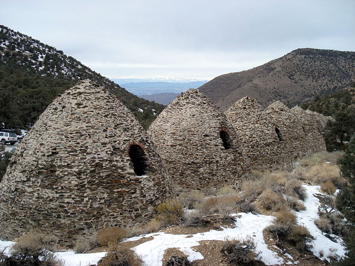
Charcoal Kilns |
|
|
|
|
|
| Alabama Hills [2009年8月] |
|
| ... |
|
|
|
|
| Manzanar & Ancient Bristlecone Pine Forest [2009年8月] |
|
![[1-41.jpg]](./manzanar%26ancient-bristlecone-pine-forest/1-24.jpg) |
|
![[1-41.jpg]](./manzanar%26ancient-bristlecone-pine-forest/1-41.jpg) |
|
![[IMG_0735+.jpg]](./ancient-bristlecones-%2709/thumbnails/IMG_0735+.jpg) |
|
| Historic Entrance, Manzanar N.H.S. |
|
Mt. Williamson and Manzanar
Cemetery |
|
Sierra View (Sierra View Vista Point) |
|
|
|
![[IMG_0761.jpg]](./ancient-bristlecones-%2709/thumbnails/IMG_0761.jpg) |
|
![[IMG_0777+.jpg]](./ancient-bristlecones-%2709/thumbnails/IMG_0777+.jpg) |
|
![[IMG_0791+.jpg]](./ancient-bristlecones-%2709/thumbnails/IMG_0791+.jpg) |
|
Cottonwood Basin Overlook
Trail, Patriarch Grove |
|
White Mountain Peak from White Mountain Road |
|
Discovery Trail, Schulman
Grove |
|
|
|
|
|
|
|
|
|
|
|
|
|
|
|
| Eastern Sierra Scenic Drive [2009年6月] |
|
![[5-12.jpg]](./canyonlands%2Carches%2Cgrand-canyon%26yosemite/5-12.jpg) |
|
![[5-20.jpg]](./canyonlands%2Carches%2Cgrand-canyon%26yosemite/5-20.jpg) |
|
![[5-25.jpg]](./canyonlands%2Carches%2Cgrand-canyon%26yosemite/5-25.jpg) |
|
| Palisades and CA State Route 168 |
|
Laurel Mountain and Convict Lake |
|
Sherwin Range from Hilltop
Hot Spring |
|
|
![[6-01.jpg]](./canyonlands%2Carches%2Cgrand-canyon%26yosemite/6-01.jpg) |
|
![[6-11.jpg]](./canyonlands%2Carches%2Cgrand-canyon%26yosemite/6-11.jpg) |
|
![[6-21.jpg]](./canyonlands%2Carches%2Cgrand-canyon%26yosemite/6-21.jpg) |
|
| Mammoth Crest and Twin Lakes |
|
Crystal Crag and Lake Mary |
|
Ellery Lake |
|
|
|
|
|
|
|
|
|
|
|
|
|
|
|
| ジョシュア・ツリー・ナショナル・パーク (Joshua Tree National Park) [2008年11月] |
|
![[DSC02000+.jpg]](./joshua-tree-np-%2708/thumbnails/DSC02000+.jpg) |
|
![[DSC02003+.jpg]](./joshua-tree-np-%2708/thumbnails/DSC02003+.jpg) |
|
![[DSC02016.jpg]](./joshua-tree-np-%2708/thumbnails/DSC02016.jpg) |
|
San Jacinto Mountains and Coachella
Valley from Keys View |
|
from Jumbo Rocks Campground |
|
Ryan Mountain summit |
|
|
![[DSC02025+26.jpg]](./joshua-tree-np-%2708/thumbnails/DSC02025+26.jpg) |
|
![[IMG_0132+.jpg]](./joshua-tree-np-%2708/thumbnails/IMG_0132+.jpg) |
|
![[IMG_0135.jpg]](./joshua-tree-np-%2708/thumbnails/IMG_0135.jpg) |
|
| from Ryan Mountain Trail |
|
Intersection Rock |
|
Cholla Cactus Garden |
|
|
|
|
|
|
|
|
|
|
|
|
|
|
|
| 20 Lakes Basin [2008年7月] |
|
![[2-06.jpg]](./may-lake%2620-lakes-basin/2-06.jpg) |
|
![[2-13.jpg]](./may-lake%2620-lakes-basin/2-13.jpg) |
|
![[2-31.jpg]](./may-lake%2620-lakes-basin/2-31.jpg) |
|
| North Peak and Saddlebag Lake |
|
Mount Conness, North Peak and Greenstone Lake |
|
North Peak and Steelhead Lake |
|
|
![[2-34.jpg]](./may-lake%2620-lakes-basin/2-34.jpg) |
|
![[2-35.jpg]](./may-lake%2620-lakes-basin/2-35.jpg) |
|
![[2-36.jpg]](./may-lake%2620-lakes-basin/2-36.jpg) |
|
| Tioga Crest, Lake Helen and Excelsior Lake |
|
Shepherd Crest and Potter Lake |
|
North Peak and Cascade
Lake |
|
|
|
|
|
| May Lake [2008年8月] |
|
![[1-04.jpg]](./may-lake%2620-lakes-basin/1-04.jpg) |
|
![[1-16.jpg]](./may-lake%2620-lakes-basin/1-16.jpg) |
|
Cathedral Peak to Tenaya Peak
from May Lake Trail |
|
May Lake |
|
|
![[1-20.jpg]](./may-lake%2620-lakes-basin/1-20.jpg) |
|
![[1-22+.jpg]](./may-lake%2620-lakes-basin/1-22+.jpg) |
|
![[1-23.jpg]](./may-lake%2620-lakes-basin/1-23.jpg) |
|
Mount Hoffmann
(eastern peaks) and
May Lake |
|
Cathedral Peak to Tenaya Peak and
May Lake |
|
Cathedral Peak and May Lake |
|
|
|
|
|
| North Fork Lone Pine Creek [2008年6月] |
|
![[1-01.jpg]](./north-fork-lone-pine-creek/1-01.jpg) |
|
![[2-12.jpg]](./north-fork-lone-pine-creek/2-12.jpg) |
|
![[2-14.jpg]](./north-fork-lone-pine-creek/2-14.jpg) |
|
![[2-22.jpg]](./north-fork-lone-pine-creek/2-22.jpg) |
|
Mt. Williamson from Manzanar
Cemetery (Manzanar N.H.S.) |
|
North Fork Lone Pine Creek Trail |
|
Mammoth Peak and Tioga Lake |
|
|
|
|
|
| セコイア & キングズ・キャニオン (Sequoia & Kings Canyon) [2008年6月] |
|
![[1-16+.jpg]](./sequoia%26kings-canyon-%2708/1-16+.jpg) |
|
![[2-04.jpg]](./sequoia%26kings-canyon-%2708/2-04.jpg) |
|
![[2-33.jpg]](./sequoia%26kings-canyon-%2708/2-33.jpg) |
|
Great Western Divide from Moro Rock
Sequoia National Park |
|
General Grant Grove, Kings
Canyon National Park |
|
Kings Canyon and Highway 180
from Junction View (Giant Sequoia
National Monument) |
|
|
|
|
|
| Long Valley [2008年5月] |
|
![[2-12.jpg]](./lyell-fork%26sherwin-range/2-12.jpg) |
|
|
|
| Sierra Nevada from Obsidian Dome |
|
|
|
![[2-41.jpg]](./lyell-fork%26sherwin-range/2-41.jpg) |
|
|
|
| Sherwin Range (Mount Morgan, Mount Morrison and Laurel Mountain) from Owens River Road |
|
|
|
|
|
|
| Alabama Hills & Southern Sierra [2008年4月] |
|
![[2-06.jpg]](./alabama-hills%26southern-sierra/2-06.jpg) |
|
![[2-12.jpg]](./alabama-hills%26southern-sierra/2-12.jpg) |
|
![[2-15.jpg]](./alabama-hills%26southern-sierra/2-15.jpg) |
|
| Lone Pine Peak and Mount Whitney from Alabama Hills |
|
Mount Whitney from Whitney
Portal Road |
|
Kennedy Meadows Campground |
|
|
|
|
|
|
|
|
|
|
|
|
|
|
|
| Eastern Sierra Scenic Drive [2007年5月] |
|
![[1-54.jpg]](./tioga-road%26convict-lake/1-54.jpg) |
|
![[1-83.jpg]](./tioga-road%26convict-lake/1-83.jpg) |
|
![[2-008.jpg]](./tioga-road%26convict-lake/2-008.jpg) |
|
| Tioga Lake |
|
Rock Creek Lake |
|
Convict Lake |
|
|
![[2-016.jpg]](./tioga-road%26convict-lake/2-016.jpg) |
|
![[2-068.jpg]](./tioga-road%26convict-lake/2-068.jpg) |
|
![[2-093.jpg]](./tioga-road%26convict-lake/2-093.jpg) |
|
| Ritter Range from Minaret Vista |
|
Carson Peak and June Lake |
|
Mono Lake Tufa State Natural Reserve |
|
|
|
|
|
|
|
|
|
|
| Treasure Lakes Trail [2006年7月] |
|
![[2-15.jpg]](./treasure-lakes-trail/2-15.jpg) |
|
![[2-19.jpg]](./treasure-lakes-trail/2-19.jpg) |
|
![[2-20.jpg]](./treasure-lakes-trail/2-20.jpg) |
|
![[2-29.jpg]](./treasure-lakes-trail/2-29.jpg) |
|
Hurd Peak and
Treasure Lakes Trail |
|
Lowest Treasure Lake |
|
Mt. Johnson and Lowest Treasure
Lake |
|
South Lake from Treasure Lakes
Trail |
|
|
|
|
|
| Saline Valley [2006年6月] |
|
| ... |
|
|
|
|
|
|
|
|
|
| デス・バレー・ナショナル・パーク (Death Valley National Park) [2006年3月] |
|
 |
|
![[1-08.jpg]](./death-valley-np-%2706/1-08.jpg) |
|
![[1-09.jpg]](./death-valley-np-%2706/1-09.jpg) |
|
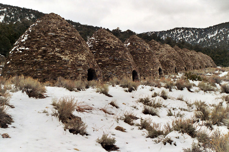
| Charcoal Kilns |
|
Salt Creek Trail |
|
Mesquite Flat Sand Dunes |
|
|
![[2-05.jpg]](./death-valley-np-%2706/2-05.jpg) |
|
![[2-09.jpg]](./death-valley-np-%2706/2-09.jpg) |
|
![[2-11.jpg]](./death-valley-np-%2706/2-11.jpg) |
|
![[2-26.jpg]](./death-valley-np-%2706/2-26.jpg) |
|
| Badwater Basin |
|
Natural Bridge Canyon |
|
Death Valley and Golden
Canyon from Golden Canyon
Trailend below Red Cathedral |
|
|
|
|
|
| First Lake of Big Pine Lakes [2005年7月] |
|
![[3-03+.jpg]](./tioga-road%26first-lake/3-03+.jpg) |
|
![[3-08.jpg]](./tioga-road%26first-lake/3-08.jpg) |
|
![[3-11.jpg]](./tioga-road%26first-lake/3-11.jpg) |
|
![[3-13.jpg]](./tioga-road%26first-lake/3-13.jpg) |
|
| Middle Palisade from North Fork Trail |
|
Castle Crag and First Lake |
|
North Fork Trail and North Fork Big
Pine Creek |
|
|
|
|
|
| White Mountain Road [2005年7月] |
|
![[2-03+.jpg]](./tioga-road%26first-lake/2-03+.jpg) |
|
![[2-09+.jpg]](./tioga-road%26first-lake/2-09+.jpg) |
|
![[2-11.jpg]](./tioga-road%26first-lake/2-11.jpg) |
|
| Sierra Nevada from Sierra View Vista Point |
|
White Mountain Peak and White Mountain
Road |
|
short climb off the Road |
|
|
|
|
|
| Mammoth Mountain [2003年6月] |
|
![[2-06.jpg]](./mammoth-mountain/2-06.jpg) |
|
![[2-09.jpg]](./mammoth-mountain/2-09.jpg) |
|
![[2-11.jpg]](./mammoth-mountain/2-11.jpg) |
|
Ritter Range from Mammoth Mountain
summit |
|
Mammoth Crest and Mammoth Lakes |
|
|
|
|
|
| Tioga Lake & June Lake Loop [2002年5月] |
|
![[1-20.jpg]](./tioga-lake%26june-lake-loop/1-20.jpg) |
|
![[2-13.jpg]](./tioga-lake%26june-lake-loop/2-13.jpg) |
|
![[2-19.jpg]](./tioga-lake%26june-lake-loop/2-19.jpg) |
|
| Mount Dana and Tioga Lake |
|
Carson Peak, Silver Lake and June
Lake Loop |
|
Mono Lake and Highway 395 from
Mono Lake Vista |
|
|
|
|
|
| Kearsarge Pass [2000年9月] |
|
![[GilbertLake-01.jpg]](../eastern-sierra/GilbertLake-01.jpg) |
|
![[NamelessPyramid-03.jpg]](../eastern-sierra/NamelessPyramid-03.jpg) |
|
![[KearsargePass-01.jpg]](../eastern-sierra/KearsargePass-01.jpg) |
|
| Nameless Pyramid and Gilbert Lake |
|
Nameless Pyramid from Kearsarge
Pass |
|
Kearsarge Pinnacles and Kearsarge
Lakes (Sequoia National Park)
from Kearsarge Pass |
|
|
|
|
|
| Ruby Lake & Mono Pass [2000年8月] |
|
![[MonoPassTrail-02.jpg]](../eastern-sierra/MonoPassTrail-02.jpg) |
|
![[RubyLake-05.jpg]](../eastern-sierra/RubyLake-05.jpg) |
|
![[MonoPass_S-01.jpg]](../eastern-sierra/MonoPass_S-01.jpg) |
|
Mono Pass Trail junction with Morgan
Pass Trail |
|
Ruby Lake from Mono Pass Trail |
|
Mono Pass |
|
|
|
|
|
| Gaylor Peak [2000年7月] |
|
![[MountDana-03.jpg]](../yosemite/MountDana-03.jpg) |
|
![[MammothPeak-06.jpg]](../yosemite/MammothPeak-06.jpg) |
|
![[CathedralRange-03.jpg]](../yosemite/CathedralRange-03.jpg) |
|
Mount Dana from Gaylor Peak
summit |
|
Kuna Crest and Mammoth Peak |
|
Cathedral Range and Gaylor Lakes |
|
|
![[GraniteLakes-01.jpg]](../yosemite/GraniteLakes-01.jpg) |
|
![[TiogaLake-03.jpg]](../eastern-sierra/TiogaLake-03.jpg) |
|
![[GaylorPeak-02.jpg]](../yosemite/GaylorPeak-02.jpg) |
|
| Peak 11,887 and Granite Lakes |
|
Tioga Peak and Tioga Lake |
|
Gaylor Peak summit |
|
|
|
|
|
| Greenstone Lake [2000年7月] |
|
![[SaddlebagLake-01.jpg]](../eastern-sierra/SaddlebagLake-01.jpg) |
|
![[ConnessLakesTrail-05.jpg]](../eastern-sierra/ConnessLakesTrail-05.jpg) |
|
![[GreenstoneLake-01.jpg]](../eastern-sierra/GreenstoneLake-01.jpg) |
|
| Saddlebag Lake |
|
Shepherd Crest and Excelsior
Mountain from Conness Lakes Trail |
|
North Peak and Greenstone Lake |
|
|
|
|
|
| Piute Pass Trail [2000年7月] |
|
![[MountEmerson-02.jpg]](../eastern-sierra/MountEmerson-02.jpg) |
|
![[LostLakesPeak-01.jpg]](../eastern-sierra/LostLakesPeak-01.jpg) |
|
![[PiuteLake-01.jpg]](../eastern-sierra/PiuteLake-01.jpg) |
|
Mount Emerson
and Loch Leven |
|
Lost Lakes Peak from Piute Pass Trail |
|
Piute Pass and Piute Lake |
|
|
|
|
|
| Hall Natural Area & Mammoth Lakes [2000年6月] |
|
![[GreenTrebleLake-02.jpg]](../eastern-sierra/GreenTrebleLake-02.jpg) |
|
![[LakeMary-03.jpg]](../eastern-sierra/LakeMary-03.jpg) |
|
![[MinaretVista-01.jpg]](../eastern-sierra/MinaretVista-01.jpg) |
|
Mount Conness and Green Treble
Lake |
|
Crystal Crag and Lake George |
|
Ritter Range from Minaret Vista |
|
|
|
|
|
| Big Pine Lakes [1997年6月] |
|
| ... |
|
|
|
|
| ヨセミテ・ナショナル・パーク [1996年8月] |
|
![[34.jpg]](../../photos/albums/tenaya-peak/34.jpg) |
|
![[33.jpg]](../../photos/albums/tenaya-peak/33.jpg) |
|
![[36.jpg]](../../photos/albums/tenaya-peak/36.jpg) |
|
Tenaya Lake from Tenaya Peak
summit |
|
Mount Conness and Cathedral Peak |
|
Clouds Rest and Half Dome |
|
|
|
|
|
| Saline Valley [1996年3月] |
|
| ... |
|
|
|
|
| ヨセミテ・ナショナル・パーク [1995年6 - 9月] |
|
![[15.jpg]](./4-mile-trail%26panorama-trail/15.jpg) |
|
![[1-14.jpg]](./upper-yosemite-fall%26north-dome/1-14.jpg) |
|
![[2-28.jpg]](./nevada-fall%26half-dome/2-28.jpg) |
|
![[2-13.jpg]](./yosemite-valley%26chilnualna-falls/2-13.jpg) |
|
Yosemite Falls from
4-Mile Trail |
|
Upper Yosemite Fall
/ Yosemite Falls Trail |
|
Half Dome summit |
|
Upper Chilnualna Fall |
|
|
![[1-34.jpg]](./lembert-dome%26glen-aulin/1-34.jpg) |
|
![[3-32.jpg]](./lembert-dome%26glen-aulin/3-32.jpg) |
|
![[2-30.jpg]](./half-dome%26quarter-domes/2-30.jpg) |
|
| from Lembert Dome summit |
|
White Cascades / Tuolumne River |
|
Half Dome summit |
|
|
![[2-02.jpg]](./cathedral-lakes%26cathedral-peak/2-02.jpg) |
|
![[2-34.jpg]](./young-lakes%26mount-conness/2-34.jpg) |
|
![[3-19.jpg]](./peeler-lake%26matterhorn-peak/3-19.jpg) |
|
Cathedral Peak and Upper Cathedral
Lake |
|
Mount Conness |
|
Matterhorn Peak and Burro Pass |
|
|
|
|
|
| Death Valley National Park [1992年6月] |
|
| ... |
|
|
|
|
| Death Valley National Monument [1990年12月] |
|
| ... |
|
|
|
|
| Joshua Tree National Monument [1990年12月] |
|
| ... |
|
|
|
|
|
|
![[albums]](./images/albums.jpg)
![[itoda.com]](./images/itoda.com.jpg)
![[ca.gov.png]](./images/ca.gov.png)
![[wikipedia.org]](./images/wikipedia.org.png)
![[wikivoyage.org]](./images/wikivoyage.org.png)
![[wikitravel.org]](./images/wikitravel.org.png)
![[visitcalifornia.com]](./images/visitcalifornia.com.png)
![[commons.wikimedia.org]](./images/commons.wikimedia.org.png)
![[IMG_0919.jpg]](./mojave-np-%2719/IMG_0919.jpg)
![[IMG_0921.jpg]](./mojave-np-%2719/IMG_0921.jpg)
![[IMG_1320+.jpg]](./mojave-np-%2719/IMG_1320+.jpg)
![[IMG_0923.jpg]](./mojave-np-%2719/IMG_0923.jpg)
![[IMG_0826.jpg]](./mojave-np-%2719/IMG_0826.jpg)
![[IMG_0827.jpg]](./mojave-np-%2719/IMG_0827.jpg)
![[IMG_9716+.jpg]](./pct-2018/d42/IMG_9716+.jpg)
![[IMG_3671.jpg]](./pct-2018/d81/IMG_3671.jpg)
![[IMG_0226_6.jpg]](./pct-2018/d83/IMG_0226_6.jpg)
![[IMG_5075+76.jpg]](./pct-2018/d95/IMG_5075+76.jpg)
![[IMG_7094+.jpg]](./pct-2018/d118/IMG_7094+.jpg)
![[IMG_0519.jpg]](./pct-2018/d136/IMG_0519.jpg)
![[IMG_4053+.jpg]](./pct-2018/d83/IMG_4053+.jpg)
![[IMG_4499_1.jpg]](./pct-2018/d86/IMG_4499_1.jpg)
![[IMG_4839+.jpg]](./pct-2018/d90/IMG_4839+.jpg)
![[IMG_5784+.jpg]](./pct-2018/d104/IMG_5784+.jpg)
![[IMG_6011.jpg]](./pct-2018/d106/IMG_6011.jpg)
![[IMG_0381.jpg]](./pct-2018/d107/IMG_0381.jpg)
![[IMG_2478+.jpg]](./pct-2018/d71/IMG_2478+.jpg)
![[IMG_2506.jpg]](./pct-2018/d71/IMG_2506.jpg)
![[IMG_2538.jpg]](./pct-2018/d71/IMG_2538.jpg)
![[IMG_0166.jpg]](./pct-2018/d71/IMG_0166.jpg)
![[IMG_2568.jpg]](./pct-2018/d71/IMG_2568.jpg)
![[IMG_2574.jpg]](./pct-2018/d71/IMG_2574.jpg)
![[IMG_7024.jpg]](./angeles-crest-hwy-2/IMG_7024.jpg)
![[IMG_7079.jpg]](./angeles-crest-hwy-2/IMG_7079.jpg)
![[IMG_7103+.jpg]](./angeles-crest-hwy-2/IMG_7103+.jpg)
![[IMG_5024.jpg]](./pinnacles-np-%2717/IMG_5024.jpg)
![[IMG_5041+.jpg]](./pinnacles-np-%2717/IMG_5041+.jpg)
![[IMG_5071+.jpg]](./pinnacles-np-%2717/IMG_5071+.jpg)
![[IMG_2956.jpg]](./pinnacles-np-%2717/IMG_2956.jpg)
![[IMG_5101.jpg]](./pinnacles-np-%2717/IMG_5101.jpg)
![[IMG_2967+.jpg]](./pinnacles-np-%2717/IMG_2967+.jpg)
![[IMG_4903.jpg]](./death-valley-np-%2717/IMG_4903.jpg)
![[IMG_4910.jpg]](./death-valley-np-%2717/IMG_4910.jpg)
![[IMG_4918.jpg]](./death-valley-np-%2717/IMG_4918.jpg)
![[IMG_4929.jpg]](./death-valley-np-%2717/IMG_4929.jpg)
![[IMG_4931.jpg]](./death-valley-np-%2717/IMG_4931.jpg)
![[IMG_4932.jpg]](./death-valley-np-%2717/IMG_4932.jpg)
![[IMG_4933.jpg]](./death-valley-np-%2717/IMG_4933.jpg)
![[IMG_4868+.jpg]](./eastern-sierra-%2717/IMG_4868+.jpg)
![[IMG_4869.jpg]](./eastern-sierra-%2717/IMG_4869.jpg)
![[IMG_4870.jpg]](./eastern-sierra-%2717/IMG_4870.jpg)
![[IMG_4833.jpg]](./alabama-hills-%2717/IMG_4833.jpg)
![[IMG_4834.jpg]](./alabama-hills-%2717/IMG_4834.jpg)
![[IMG_4837.jpg]](./alabama-hills-%2717/IMG_4837.jpg)
![[IMG_4844.jpg]](./alabama-hills-%2717/IMG_4844.jpg)
![[IMG_4852.jpg]](./alabama-hills-%2717/IMG_4852.jpg)
![[IMG_2888.jpg]](./alabama-hills-%2717/IMG_2888.jpg)
![[IMG_4207.jpg]](./joshua-tree-np-%2716//IMG_4207.jpg)
![[IMG_4268+.jpg]](./joshua-tree-np-%2716/IMG_4268+.jpg)
![[IMG_4338.jpg]](./joshua-tree-np-%2716/IMG_4338.jpg)
![[IMG_4459+60.jpg]](./joshua-tree-np-%2716/IMG_4459+60.jpg)
![[IMG_4481+.jpg]](./joshua-tree-np-%2716/IMG_4481+.jpg)
![[IMG_4038.jpg]](./yosemite%26san-francisco/IMG_4038.jpg)
![[IMG_4064.jpg]](./yosemite%26san-francisco/IMG_4064.jpg)
![[IMG_4069+.jpg]](./yosemite%26san-francisco/IMG_4069+.jpg)
![[IMG_1756.jpg]](./tioga-pass-road-%2716/IMG_1756.jpg)
![[IMG_2555.jpg]](./tioga-pass-road-%2716/IMG_2555.jpg)
![[IMG_2632.jpg]](./tioga-pass-road-%2716/IMG_2632.jpg)
![[IMG_2476.jpg]](./tioga-pass-road-%2716/IMG_2476.jpg)
![[IMG_2478.jpg]](./tioga-pass-road-%2716/IMG_2478.jpg)
![[IMG_2481.jpg]](./tioga-pass-road-%2716/IMG_2481.jpg)
![[IMG_2268.jpg]](./ancient-bristlecones-%2716/IMG_2268.jpg)
![[IMG_2273+.jpg]](./ancient-bristlecones-%2716/IMG_2273+.jpg)
![[IMG_2275+.jpg]](./ancient-bristlecones-%2716/IMG_2275+.jpg)
![[IMG_2294+.jpg]](./ancient-bristlecones-%2716/IMG_2294+.jpg)
![[IMG_2330+.jpg]](./ancient-bristlecones-%2716/IMG_2330+.jpg)
![[IMG_2352+.jpg]](./ancient-bristlecones-%2716/IMG_2352+.jpg)
![[IMG_2380+.jpg]](./ancient-bristlecones-%2716/IMG_2380+.jpg)
![[IMG_2138+.jpg]](./manzanar-%2716/IMG_2138+.jpg)
![[IMG_2147+.jpg]](./manzanar-%2716/IMG_2147+.jpg)
![[IMG_2158.jpg]](./manzanar-%2716/IMG_2158.jpg)
![[IMG_2174.jpg]](./manzanar-%2716/IMG_2174.jpg)
![[IMG_2178++.jpg]](./manzanar-%2716/IMG_2178++.jpg)
![[IMG_2192.jpg]](./manzanar-%2716/IMG_2192.jpg)
![[IMG_1637+.jpg]](./alabama-hills-%2716/IMG_1637+.jpg)
![[IMG_2079+.jpg]](./alabama-hills-%2716/IMG_2079+.jpg)
![[IMG_2081.jpg]](./alabama-hills-%2716/IMG_2081.jpg)
![[IMG_1773+.jpg]](./pinnacles-np-%2716/IMG_1773+.jpg)
![[IMG_1806.jpg]](./pinnacles-np-%2716/IMG_1806.jpg)
![[IMG_1826.jpg]](./pinnacles-np-%2716/IMG_1826.jpg)
![[IMG_1465_2.jpg]](./pinnacles-np-%2716/IMG_1465_2.jpg)
![[IMG_1867.jpg]](./pinnacles-np-%2716/IMG_1867.jpg)
![[IMG_1604+.jpg]](./hetch-hetchy-valley-%2716/IMG_1604+.jpg)
![[IMG_1610+.jpg]](./hetch-hetchy-valley-%2716/IMG_1610+.jpg)
![[IMG_1628.jpg]](./hetch-hetchy-valley-%2716/IMG_1628.jpg)
![[IMG_1656.jpg]](./hetch-hetchy-valley-%2716/IMG_1656.jpg)
![[IMG_1670.jpg]](./hetch-hetchy-valley-%2716/IMG_1670.jpg)
![[IMG_1729+.jpg]](./hetch-hetchy-valley-%2716/IMG_1729+.jpg)
![[IMG_0986.jpg]](./ancient-bristlecones-%2715/IMG_0986.jpg)
![[IMG_0991+.jpg]](./ancient-bristlecones-%2715/IMG_0991+.jpg)
![[IMG_0884.jpg]](./ancient-bristlecones-%2715/IMG_0884.jpg)
![[IMG_2334++.jpg]](./alabama-hills-%2714/IMG_2334++.jpg)
![[IMG_2338+.jpg]](./alabama-hills-%2714/IMG_2338+.jpg)
![[IMG_2384+.jpg]](./alabama-hills-%2714/IMG_2384+.jpg)
![[IMG_2389.jpg]](./alabama-hills-%2714/IMG_2389.jpg)
![[IMG_2399.jpg]](./alabama-hills-%2714/IMG_2399.jpg)
![[IMG_2404+.jpg]](.//alabama-hills-%2714/IMG_2404+.jpg)
![[IMG_2266++.jpg]](./manzanar-%2714/IMG_2266++.jpg)
![[IMG_2273+.jpg]](./manzanar-%2714/IMG_2273+.jpg)
![[IMG_2282+.jpg]](./manzanar-%2714/IMG_2282+.jpg)
![[IMG_0845+.jpg]](./pinnacles-np-%2714/IMG_0845+.jpg)
![[IMG_0852+.jpg]](./pinnacles-np-%2714/IMG_0852+.jpg)
![[IMG_0853.jpg]](./_pinnacles-np-%2714/IMG_0853.jpg)
![[IMG_0554.jpg]](./joshua-tree-np-%2714/IMG_0554.jpg)
![[IMG_0553.jpg]](./joshua-tree-np-%2714/IMG_0553.jpg)
![[IMG_0559+.jpg]](./joshua-tree-np-%2714/IMG_0559+.jpg)
![[IMG_0560+.jpg]](./joshua-tree-np-%2714/IMG_0560+.jpg)
![[IMG_0564+.jpg]](./joshua-tree-np-%2714/IMG_0564+.jpg)
![[IMG_0566++.jpg]](./joshua-tree-np-%2714/IMG_0566++.jpg)
![[DSC04653+++.jpg]](./manzanar-%2713/DSC04653+++.jpg)
![[DSC04668.jpg]](./manzanar-%2713/DSC04668.jpg)
![[DSC04670+.jpg]](./manzanar-%2713/DSC04670+.jpg)
![[DSC04648+.jpg]](./alabama-hills-%2713/DSC04648+.jpg)
![[DSC04684.jpg]](./alabama-hills-%2713/DSC04684.jpg)
![[DSC04685.jpg]](./alabama-hills-%2713/DSC04685.jpg)
![[DSC04688+.jpg]](./alabama-hills-%2713/DSC04688+.jpg)
![[DSC04694.jpg]](./alabama-hills-%2713/DSC04694.jpg)
![[DSC04705.jpg]](./alabama-hills-%2713/DSC04705.jpg)
![[DSC04084.jpg]](./lassen-volcanic-np-%2712/DSC04084.jpg)
![[DSC04086.jpg]](./lassen-volcanic-np-%2712/DSC04086.jpg)
![[DSC04115+.jpg]](./lassen-volcanic-np-%2712/DSC04115+.jpg)
![[DSC04156.jpg]](./lassen-volcanic-np-%2712/DSC04156.jpg)
![[DSC04162.jpg]](./lassen-volcanic-np-%2712/DSC04162.jpg)
![[DSC04173.jpg]](./lassen-volcanic-np-%2712/DSC04173.jpg)
![[IMG_3853.jpg]](./pinnacles-nm-%2712/IMG_3853.jpg)
![[IMG_3856+.jpg]](./pinnacles-nm-%2712/IMG_3856+.jpg)
![[IMG_3864.jpg]](./pinnacles-nm-%2712/IMG_3864.jpg)
![[1-14+.jpg]](./mojave-nat%27l-preserve%26death-valley-nat%27l-park/1-14+.jpg)
![[1-21+.jpg]](./mojave-nat%27l-preserve%26death-valley-nat%27l-park/1-21+.jpg)
![[2-015+.jpg]](./lake-sabrina%2Clittle-lakes-valley%26tj-barrett-lakes/2-015+.jpg)
![[2-042.jpg]](./lake-sabrina%2Clittle-lakes-valley%26tj-barrett-lakes/2-042.jpg)
![[2-150+.jpg]](./lake-sabrina%2Clittle-lakes-valley%26tj-barrett-lakes/2-150+.jpg)
![[2-162.jpg]](./lake-sabrina%2Clittle-lakes-valley%26tj-barrett-lakes/2-162.jpg)
![[3-057.jpg]](./lake-sabrina%2Clittle-lakes-valley%26tj-barrett-lakes/3-057.jpg)
![[067.jpg]](./lake-sabrina%2Clittle-lakes-valley%26tj-barrett-lakes/3-067.jpg)
![[2-086+.jpg]](./golden-trout-lakes-trail%2Cmono-lake%26fairview-dome/2-086+.jpg)
![[2-108.jpg]](./golden-trout-lakes-trail%2Cmono-lake%26fairview-dome/2-108.jpg)
![[2-115.jpg]](./golden-trout-lakes-trail%2Cmono-lake%26fairview-dome/2-115.jpg)
![[IMG_1080+.jpg]](./manzanar-%2710/IMG_1080+.jpg)
![[IMG_1081.jpg]](./manzanar-%2710/IMG_1081.jpg)
![[IMG_1085.jpg]](./manzanar-%2710/IMG_1085.jpg)
![[1-015.jpg]](./golden-trout-lakes-trail%2Cmono-lake%26fairview-dome/1-015.jpg)
![[IMG_1069++.jpg]](./eastern-sierra-%2710/IMG_1069++.jpg)
![[IMG_1079++.jpg]](./eastern-sierra-%2710/IMG_1079++.jpg)
![[IMG_1070++.jpg]](./eastern-sierra-%2710/IMG_1070++.jpg)
![[DSC02602+.jpg]](./eastern-sierra-%2710/DSC02602+.jpg)
![[2-086.jpg]](./sentinel-dome%2Cdevils-postpile%2620-lakes-basin/2-086.jpg)
![[IMG_0735+.jpg]](./ancient-bristlecones-%2709/IMG_0735+.jpg)
![[IMG_0761.jpg]](./ancient-bristlecones-%2709/IMG_0761.jpg)
![[IMG_0777+.jpg]](./ancient-bristlecones-%2709/IMG_0777+.jpg)
![[IMG_0791+.jpg]](./ancient-bristlecones-%2709/IMG_0791+.jpg)
![[6-29.jpg]](./canyonlands%2Carches%2Cgrand-canyon%26yosemite/6-29.jpg)
![[6-37.jpg]](./canyonlands%2Carches%2Cgrand-canyon%26yosemite/6-37.jpg)
![[6-46+.jpg]](./canyonlands%2Carches%2Cgrand-canyon%26yosemite/6-46+.jpg)
![[18.jpg]](./ebbetts-pass%26carson-pass/18.jpg)
![[26.jpg]](./ebbetts-pass%26carson-pass/26.jpg)
![[36.jpg]](./ebbetts-pass%26carson-pass/36.jpg)
![[5-20.jpg]](./canyonlands%2Carches%2Cgrand-canyon%26yosemite/5-20+.jpg)
![[2-12.jpg]](./walker-pass%26kern-canyon/2-12.jpg)
![[2-23.jpg]](./walker-pass%26kern-canyon/2-23.jpg)
![[2-30.jpg]](./walker-pass%26kern-canyon/2-30.jpg)
![[40.jpg]](./yosemite-valley-%2709/40.jpg)
![[56.jpg]](./yosemite-valley-%2709/56.jpg)
![[60.jpg]](./yosemite-valley-%2709/60.jpg)
![[70.jpg]](./yosemite-valley-%2709/70.jpg)
![[DSC02000+.jpg]](./joshua-tree-np-%2708/DSC02000+.jpg)
![[DSC02003+.jpg]](./joshua-tree-np-%2708/DSC02003+.jpg)
![[DSC02016.jpg]](./joshua-tree-np-%2708/DSC02016.jpg)
![[DSC02025+26.jpg]](./joshua-tree-np-%2708/DSC02025+26.jpg)
![[IMG_0132+.jpg]](./joshua-tree-np-%2708/IMG_0132+.jpg)
![[IMG_0135.jpg]](./joshua-tree-np-%2708/IMG_0135.jpg)
![[1-14.jpg]](./virginia-lakes%26crystal-lake-trail/1-14.jpg)
![[2-20.jpg]](./virginia-lakes%26crystal-lake-trail/2-20.jpg)
![[1-04.jpg]](./death-valley-np-%2708/1-04.jpg)
![[1-09.jpg]](./death-valley-np-%2708/1-09.jpg)
![[2-07.jpg]](./death-valley-np-%2708/2-07.jpg)
![[2-12.jpg]](./death-valley-np-%2708/2-12.jpg)
![[2-24.jpg]](./death-valley-np-%2708/2-24.jpg)
![[3-06.jpg]](./death-valley-np-%2708/3-06.jpg)
![[1-37.jpg]](./lone-pine%26upper-boy-scout-lake/1-37.jpg)
![[2-046.jpg]](./lone-pine%26upper-boy-scout-lake/2-046.jpg)
![[2-068.jpg]](./lone-pine%26upper-boy-scout-lake/2-068.jpg)
![[1-30.jpg]](./sonora-pass%26mono-lake/1-30.jpg)
![[2-052.jpg]](./sonora-pass%26mono-lake/2-052.jpg)
![[2-109.jpg]](./sonora-pass%26mono-lake/2-109.jpg)
![[2-08.jpg]](./alabama-hills%26manzanar/2-08.jpg)
![[2-15.jpg]](./alabama-hills%26manzanar/2-15.jpg)
![[2-41.jpg]](./alabama-hills%26manzanar/2-41.jpg)
![[2-47.jpg]](./alabama-hills%26manzanar/2-47.jpg)
![[2.jpg]](./lava-beds-nm/2.jpg)
![[4.jpg]](./lava-beds-nm/4.jpg)
![[5.jpg]](./lava-beds-nm/5.jpg)
![[3-08.jpg]](./tioga-road%26first-lake/3-08+.jpg)
![[2-19.jpg]](./tioga-lake%26june-lake-loop/2-19+.jpg)
![[2-14.jpg]](./cottonwood-lakes-trail/2-14.jpg)
![[ja]](./images/japanese_black.gif)
![[en]](./images/english_white.gif)